RESEARCH
I’m an ecologist interested in landscape processes and the impacts of natural and human factors on freshwater and terrestrial ecosystems and how these factors shape community structure, function, and ecosystem services of freshwater and terrestrial systems. I focus on developing statistical and spatial models along with conservation strategies of freshwater and terrestrial ecosystems to bridge gaps between ecological theory and large datasets to inform applied management of natural resources.
Project: Mapping an Index of Watershed Integrity for the conterminous United States
Index of Watershed Integrity Web Application: Web App
Collaborators: Scott G. Leibowitz, Ryan A. Hill, Marc H. Weber, Zachary C. Johnson, Anthony R. Olsen, Joseph E. Flotemersch, John L. Stoddard, and David V. Peck
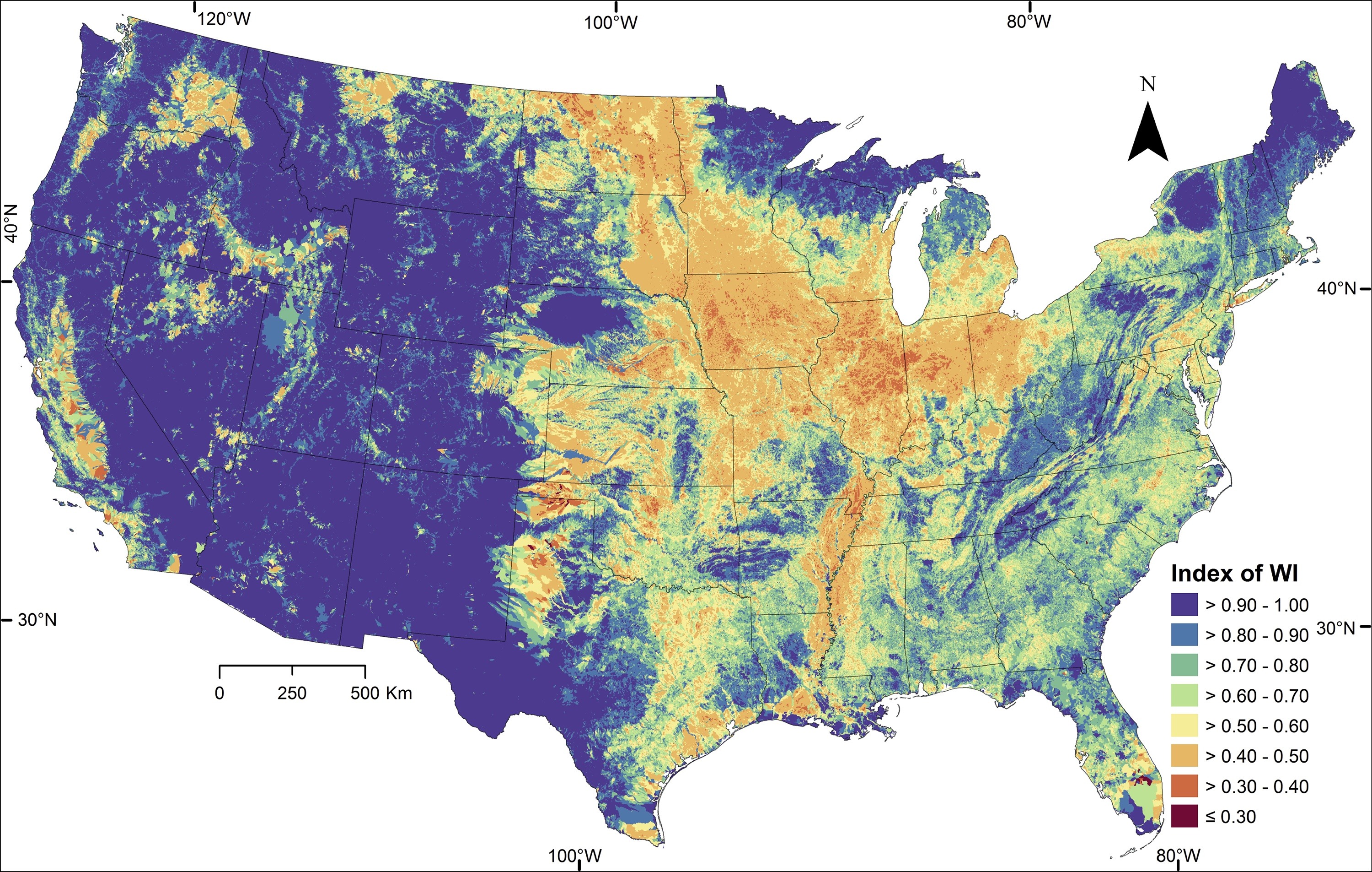 Fig. 3. Thornbrugh et al. 2018, Index of Watershed Integrity for the conterminous United States showing higher integrity in bluer colors, moderate integrity in yellows, and lower integrity in redder colors. Because watersheds of consecutive stream segments are nested and overlap, each value is mapped onto the most downstream catchment within each watershed.
Project: Red Relief Image Map (RRIM) for northeast Minnesota for Chippewa and Superior National Forests
Collaborators: Darren Thornbrugh and Trevor Hobbs
Developer and Author: Darren Thornbrugh
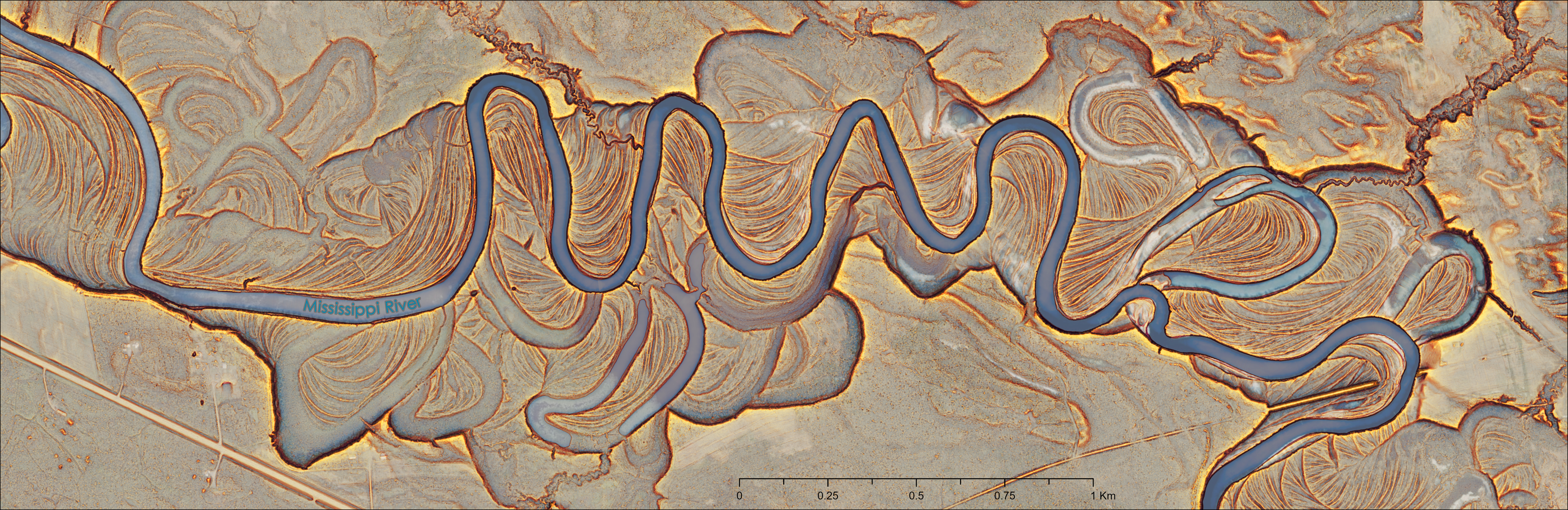 Image 1. Red Relief Image Map of the Mississippi River and floodplain in Minnesota near Jacobson MN, southeast of Grand Rapids, MN.
Summary: Red Relief Image Map (RRIM) is a visualization method for topography data that enhances the three dimensional (3D) visual in a single image. The RRIM applies a chroma of red color to a slope gradient and overlays over an openness index giving enhanced 3D appearance (Conrad et al. 2015, Chiba et al. 2008, Yokoyama et al., 2002). This topography visualization technique exaggerates relative relief, highlighting ridges and valleys, breaks in landform characteristics, interpretation of topographic features, and built infrastructure. The RRIM can be calculated from detailed Lidar derived digital elevation model (DEM) and other DEM products.
The RRIM can express details of topography by single image map and has overcome some of the shortness of traditional topographic visualization methods like light direction dependence from hill-shading, weakness for scaling and poor expression for flat or steep relief from contour lines, distinguishing convex and concave from slope gradient, and removes need for additional stereoscope and filtering devices for viewing.
The RRIM effectively represents topographic data in a shade free 3D single image, clearly showing convexity, concavity, and representing fine topographic structure in flat surfaces, improving interpretation of topographic features.
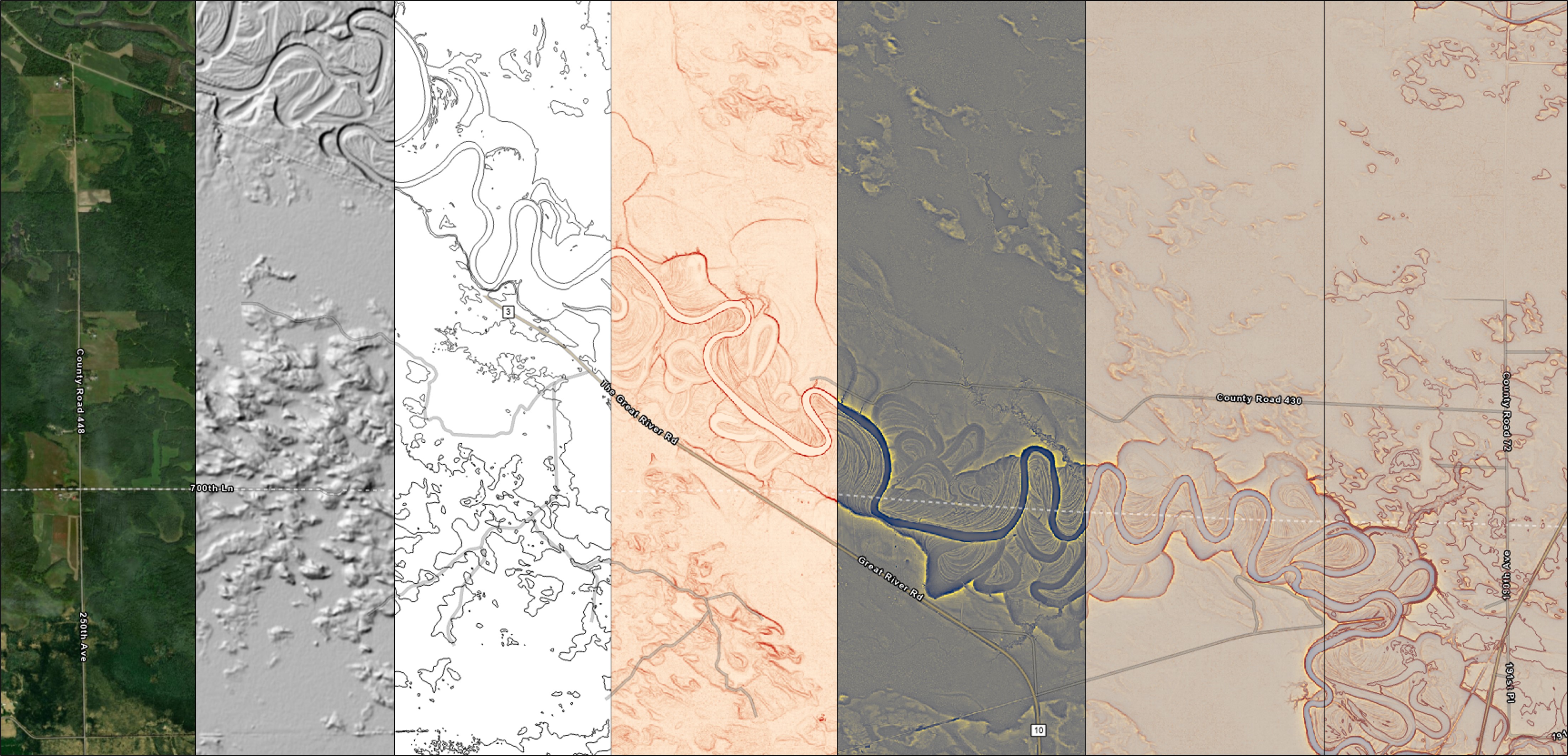 Image 2. Photo progression comparing visual outputs for Imagery, Hill-shade, Contours, Slope gradient, Openness index, Red Relief Image Map (RRIM), and RRIM + Contours
Project: Geomorphon development for the Forest Service Eastern Region National Forests
Developer and Author: Darren Thornbrugh
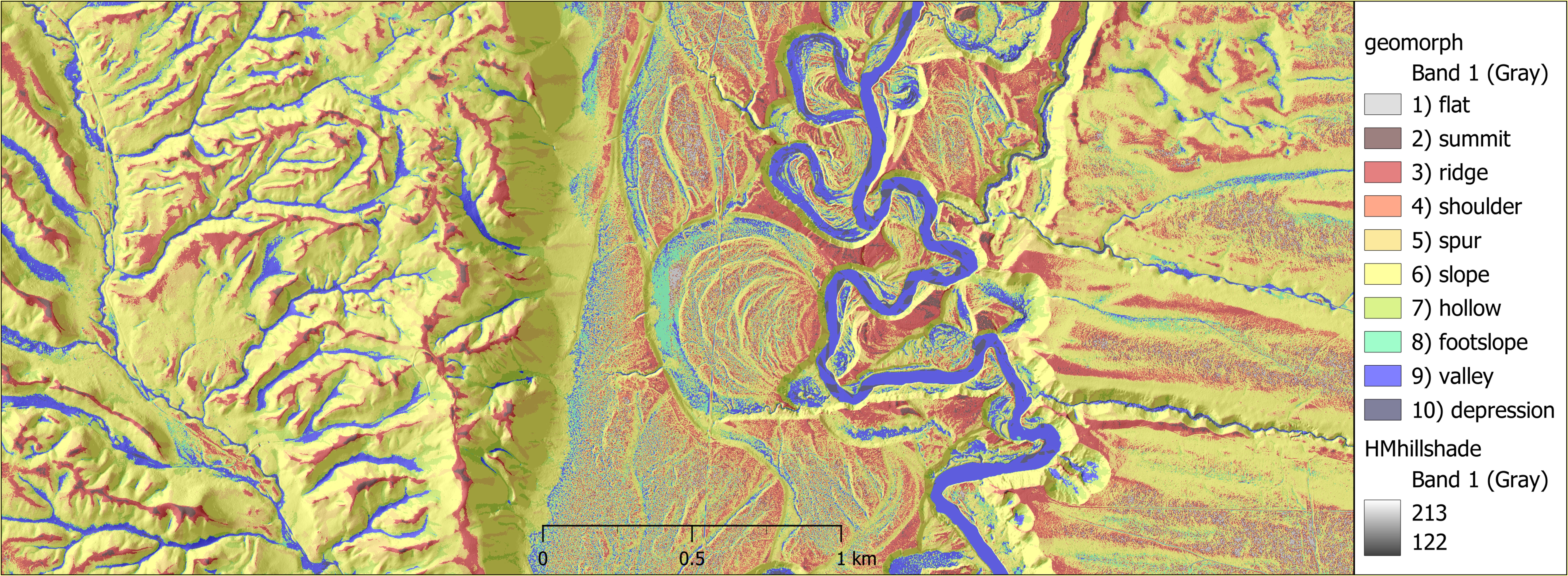 Image 1. Geomorphons of the Manistee River near Manistee, Michigan on Huron-Manistee National Forest.
Summary: Geomorphons (geomorphologic phonotypes): Geomorphons classify topographic landform elements and map terrain morphology from simple local ternary patterns (Jasiewicz and Stepinski 2013). From an elevation model you can look at the patterns of surrounding cells from each cell and determine if the neighborhood cells are higher, lower, or the same height. You can reclassify the elevation model from the local ternary patterns into basic morphological patterns (e.g., flat, summit, ridge, shoulder, spur, slope, hollow, footslope, valley, depression). You can colorize your morphologic classes and map the results creating a general purpose geomorphometric map of the most common landform morphological elements.
Jasiewicz, J. and Stepinski, T.F., 2013. Geomorphons—a pattern recognition approach to classification and mapping of landforms. Geomorphology, 182, pp.147-156.
RESEARCH GOALS
- The application of aquatic landscape ecology to biodiversity conservation and management of natural resources.
- Further refine the use of community assembly and trait-based ecology in an effort to conserve the biodiversity, function, and services of freshwater ecosystems.
- Bridging gaps between community structure and ecological theory with large spatial and community datasets.
- Application of modern statistical theory (Bayesian, multivariate and nonparametric) and modeling techniques for the use of ecology research and natural resource management.
- Integration of GIS and remote sensing with aquatic landscape ecology.
RESEARCH FOCUS
My research efforts focus on identifying and quantifying spatial patterns in the distribution in freshwater fish and macroinvertebrate communities, the natural landscape and anthropogenic processes that influence these patterns, how they change over time, and how to apply this knowledge to manage freshwater resources, preserve water quality and conserve biodiversity. Freshwater ecosystems are heterogeneous environments in which animals live, that are ever changing in response to disturbances in the landscape, knowledge of how the disturbances influence aquatic communities is essential in order to predict and responsibly manage aquatic resources.
RESEARCH INTERESTS
- Geospatial Analysis
- Forest Ecology/Vegetation Ecology
- Landscape Ecology
- Aquatic Landscape Ecology
- Watershed Integrity/Health/Resources
- Community Assembly Theory
- Trait-Based Ecology and Biological Assessment
- Fish/Macroinvertebrate Ecology
- Native Fish Species Conservation
- Native/Introduced Fish Species Interactions
- Whole Stream/River Ecology
- Water Quality
- Integrated use of GIS and Remote Sensing with Stream Ecology
EDUCATION
PhD in Fisheries & Wildlife 2009-2014. Department of Fisheries & Wildlife, College of Agriculture & Natural Resources, Michigan State University, East Lansing, Michigan
MS in Biology 2006-2007. Division of Biology, College of Arts & Sciences, Kansas State University, Manhattan, Kansas
BA in Environmental Studies 1999-2001. College of Arts & Sciences, University of Nebraska, Lincoln, Nebraska
BS in Geography 1994-2000. Minor: Biology, College of Arts & Sciences, University of Nebraska, Lincoln, Nebraska
WATERSHED DATABASE - StreamCat Dataset
- Citation: Hill, Ryan A., Marc H. Weber, Scott G. Leibowitz, Anthony R. Olsen, and Darren J. Thornbrugh, 2016. The Stream-Catchment (StreamCat) Dataset: A Database of Watershed Metrics for the Conterminous United States. Journal of the American Water Resources Association (JAWRA) 1-9. DOI: 10.1111/1752-1688.12372.
- StreamCat Dataset - StreamCat
- StreamCat Dataset - Access StreamCat Data
- StreamCat Dataset - Variable list and Definitions
- StreamCat Dataset - Geospatial Framework and Terms
- StreamCat Dataset - Data by HydroRegion
- StreamCat Dataset - Data by State
- StreamCat Dataset - Table View: Metric, Area of Interest
- StreamCat Dataset - R Programming Interface
- StreamCat Dataset - Github
- Associated dataset - National Hydrography Dataset Version 2 (NHDPlusV2)
FELLOWSHIP AWARDS AND FUNDING
- Austrian Marshall Plan Foundation Scholarship. 2013. $10931, Exchange student at Institute of Hydrobiology and Aquatic Ecosystem Management, University of Natural Resources and Life Sciences (BOKU), Vienna, Austria.
- Dr. Howard A. Tanner Fisheries Excellence Fellowship. 2011-2012. $2500, Department of Fisheries and Wildlife Fellowship, Michigan State University
- Red Cedar Fly Fishers Graduate Fellowship in Fisheries Management. 2011. $1000, Red Cedar Fly Fishers, Okemos, Michigan
- Robert C. and Betty A. Ball Department of Fisheries and Wildlife Fellowship. 2010-2011. $5000, Michigan State University
- Bridge Fellowship. 2009-2010. College of Agriculture and Natural Resources, Michigan State University
- Summer Recruitment Fellowship. 2009. College of Agriculture and Natural Resources, Michigan State University
COURSE INSTRUCTION
- 2013 Hydrobiology (in Eng.), guest teaching assistant, Institute of Hydrobiology and Aquatic Ecosystem Management, University of Natural Resources and Life Sciences (BOKU), Vienna, Austria.
- 2011 Ichthyology Lab guest lecture x2, Teaching Assistant, Michigan State University, East Lansing, Michigan
- 2010 Hydrology for Watershed Management, Research Assistant, Michigan State University, East Lansing, Michigan
- 2009 Aquatic Ecosystem Management, guest lecture x1 Teaching Assistant, Michigan State University, East Lansing Michigan
- 2006 - 2007 Principles of Biology, 3 semesters Graduate Teaching Assistant, Kansas State University, Manhattan, Kansas