High‑Performance Terrain Visualization Engineered for Massive LiDAR & Statewide Datasets
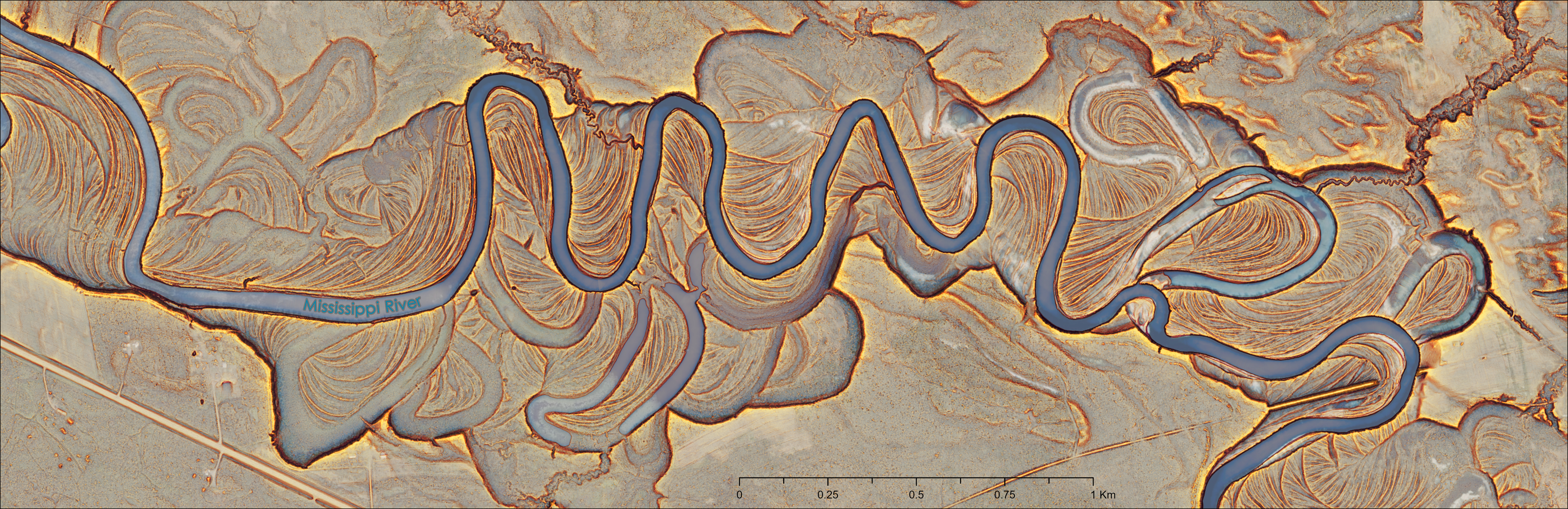 Image 1. Red Relief Image Map of the Mississippi River and floodplain in Minnesota near Jacobson MN, southeast of Grand Rapids, MN.
A major production update to the RRIM_Toolbox for ArcGIS Pro is now live. Engineered specifically for massive LiDAR-derived DEMs, statewide elevation collections, and big-data GIS production pipelines, this release introduces an end-to-end 2048 × 2048 windowed tiling engine and optimized multi-core batch processing.
🚀 What’s New in This Release
1. Unified 2048 × 2048 Windowed Tiling Architecture
- Memory-Bounded Streaming: Single-raster mode streams processing in discrete 2048 × 2048 blocks with halo buffers equal to kernel and search radii.
- Seam-Free Output: Edge-overlap math and post-index boundary smoothing eliminate tile seams, truncation, and raster collar artifacts across multi-gigabyte rasters while keeping RAM usage strictly constrained.
2. High-Speed SIMD Vectorized Openness Engine
- Streamlined Workflow: Topographic Openness now computes positive, negative, and the combined Openness Index in a single, high-throughput pass.
- Hardware Acceleration: In-place array operations cut computation times down to ~2.3 minutes on 100-megapixel (10k × 10k) tiles without RAM bloat.
3. Balanced Multi-Core Batch Processing
- Folder batch mode introduces protected queue batching that prevents external USB and network drive bottlenecks:
- Openness: Processes batches of 8 using up to 8 concurrent workers.
- Slope: Batches of 4 locked to 2 concurrent workers to prevent drive queue saturation.
- RRIM & RRIM Classic: Batches of 8 locked to 2 concurrent workers to handle dual-raster reads and 3-band writes safely.
- Real-time telemetry reports per-tile durations, remaining queue counts, moving averages, and overall elapsed times.
4. True 3-Band RGB Output with Instant Pro Symbology
- Both Custom (Cividis) and Classic (Grayscale) RRIM tools generate standard 3-band 8-bit unsigned (
GDT_Byte) GeoTIFFs with automated<PAMDataset>(DataType=Processed).aux.xmlsidecars. - No manual symbology tweaks: ArcGIS Pro immediately recognizes the output as pre-rendered RGB with
Stretch: None, avoiding unwanted 2% contrast stretches or color-cast distortions. - Transparent footprint masking ensures non-terrain boundary pixels display seamlessly over basemaps.
🛠️ The Core Tool Suite
- Topographic Openness Index — Single-pass zenith/nadir radial scanning with boundary-safe smoothing.
- Slope from DEM — Optimized 3×3 Horn slope calculator with seamless tile edge preservation.
- Red Relief Image Map (Custom) — Perceptually uniform Cividis openness blended with a chromatic red slope overlay ($\alpha = 0.7$).
- Red Relief Image Map (Classic) — High-contrast, traditionally styled grayscale openness blended with a red slope overlay, oriented for accurate, non-inverted relief perception.
📦 Dependency‑Free Architecture
Runs directly out of the box within ArcGIS Pro’s default Python environment. No extra environments, custom wheels, or external libraries required:
- ArcGIS Pro 3.x (
arcpy) - NumPy (bundled)
- GDAL / OGR (bundled)
🔗 GitHub Repository
Download the toolbox, explore the source code, and read the updated documentation:
📘 Documentation & Technical Specifications
Full parameter matrices, architectural details, and production tiling tips:
🧭 System Requirements
- Host Application: ArcGIS Pro 3.0 or later
- Python Environment: Default
arcgispro-py3(Python 3.9+) - Operating System: Windows 10 / 11 / Server 2019+
- Storage Compatibility: Local NVMe SSDs, external USB HDDs, and network storage shares (UNC paths)
Author
Darren J. Thornbrugh
USDA Forest Service — Spatial Analysis, Remote Sensing & Ecological Modeling